| Location : | Korakoram Range, Pakistan - China Border |
| Altitude : | 8,611m (28,251 ft) |
| Imporance : | 2nd Highest Mountain In The World. |
| Best Trek Season : | April To October |
K2 peak, locally known by the name of “Chogo Ri”, which means "The Great Mountain", 8,611m, is the 2nd highest mountain in the world. K2 is placed on the Pakistan - China border in the mighty Karakoram range.
With no simple routes, K2 is known as the finest and most dangerous mountain in the world. This is because of the massiveness in the size of this mountain and the numerous unsuccessful attempts made on it by various expeditions, which include mostly American expeditions.
About K2
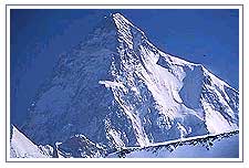 K2 is a rocky mountain up to 6,000m, beyond which it becomes an ocean of snow. The traditional route to K2's base camp goes from Skardu, which is linked with Islamabad by a good road. From Skardu the route goes via Shigar-Dassu-Askole up to Concordia over the Baltoro glacier.
K2 was firstly discovered and measured by the Survey of India in 1856, and first named for English topographer Henry Godwin - Austen, who explored and surveyed the region.
K2 is taken from the first letter of Karakorum, and the number indicates that it was the second peak in the range to be measured. K2 was firstly climbed on July,31 1954 by Italian climbers team lead by Ardito Desio and accompanying him were Lino Lacedelli and Achille Compagnoni. A March 1987 measurement of K2 indicated that it might be higher than Everest, but later that year, Everest was re-measured by a similar method and found to indeed be 778 ft (237m) taller.
The Korakoram Range
Karakorum also has several of the world's largest glaciers. Its southern slopes are the watershed for many tributaries of the Indus River. The mountains, which are the greatest barrier between India and Central Asia, are crossed above the perpetual snow line by two natural routes. Karakorum Pass (18,290 ft/5,575 m), is the chief pass on the main Kashmir - China route. Another important pass, Khunjerab (Kunjirap) Pass (15,420 ft/4,700m), is on the Pakistan - China route.
Henry Godwin-Austin
No comments:
Post a Comment